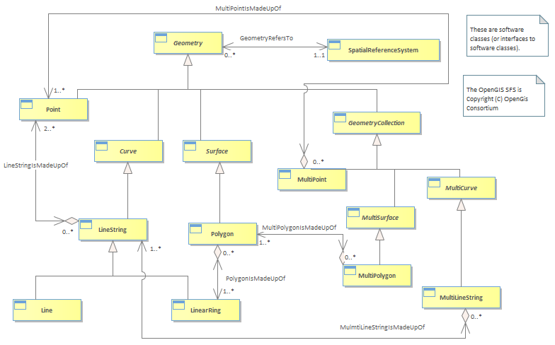
Figure L.09 - Geographic Geometry [OGIS] : Class diagram
| Created: | 3/28/2022 3:51:09 PM |
| Modified: | 6/9/2022 12:22:41 PM |
 Project: Project: |
|
| Advanced: |
This model adopts the Open GIS Consortium Geometry model [OGIS].<br/>Whilst in theory any spatial engine / model could be used, use of a standard interface allows for component interworking.<br/>Refer to document “OpenGIS® Simple Features Specification for SQL” at http://www.opengis.org/techno/implementation.htm for an explanation of the model. Note that the Geometry classes are not documented in the “data dictionary” section at the back of this document.<br/>For messaging and data interchange of Geographic information, the GML standard is recommended.<br/><i>“The Geography Markup Language (GML) is an XML encoding for the transport and storage of geographic information, including both the spatial and non-spatial properties of geographic features.” [GML]</i><br/>The Geometry classes should be considered as a closed set, with Geometry as the root class and no subclassing of any of the classes shown in fig 9. This aligns with the proposed ISO standard [ISO / DIS 19109].<br/>If a spatial engine is not available, but geocodes are required, then a Point entity could be substituted.<br/><br/>The SID model uses Geometry as an attribute of the Geographic Location entity.<br/>Astute readers will have noticed that the OGIS Geometry class implements the Binary Topological Relationships.<br/>